

/image%2F0794068%2F201310%2Fob_4d27e7abc3cb90383a2c29d6014af693_dsc-4148-m.jpg)

Figura 1. Edificio colapsado en la parroquia Tarqui (Manta) durante el sismo de Pedernales el 16/04/2016 (fotos: Juan Carlos Singaucho, IG-EPN). Este edificio tenía un piso intermedio más débil (patología llamada “piso blando”) que los pisos superiores y terminó colapsándose.
Escrito por Benjamin Bernard, revisado por Sandro Vaca
Es una de las preguntas más frecuentes que nos hacen. Aunque este blog está dedicado a los volcanes, los sismos también nos interesan, sobre todo cuando son precursores de eventos volcánicos. Los sismos son fenómenos naturales sumamente importantes. Son una de las expresiones más espectaculares de la dinámica terrestre y también pueden desencadenar grandes desastres (Fig. 1). Sin embargo, no se deben confundir, los terremotos no son los responsables de los desastres, los humanos si. Al momento de hacerse la pregunta de la diferencia entre magnitud e intensidad sísmica, esta observación es vital.
This is one of the most frequent questions. Although this blog, ceniza-ecuador.over-blog.com, is dedicated to volcanoes, earthquakes also interest us, especially when they are precursors of volcanic events. Earthquakes are extremely important natural phenomena. They are one of the most spectacular expressions of terrestrial dynamics and can also trigger great disasters (Fig. 1). However, this should not be confused, earthquakes are not responsible for disasters, humans are. When asking the question what is the difference between magnitude and seismic intensity, this observation is vital.

Figura 2. Límites de placas tectónicas (fuente: USGov).
Constantemente la superficie terrestre se mueve a velocidades muy variables (entre menos de 1 mm/año hasta más de 10 cm/año), dependiendo de su contexto geodinámico (Fig. 2). En las zonas de divergencia (eg. la dorsal Nazca-Cocos), las placas tectónicas se extienden y separan formando nueva corteza terrestre. En las zonas transformantes (eg. la falla de San Andrés en EE.UU. o la falla de Pallatanga en Ecuador), las placas tectónicas se dezolazan de manera horizontal y paralela entre si. En las zonas de convergencia (eg. la subducción de la placa Nazca debajo de Sudamérica), las placas tectónicas se chocan, se doblan y se introducen las unas por debajo de las otras. Durante estos movimientos las placas tectónicas son deformadas, en un primer momento de forma elástica (como doblar una rama de árbol) pero cuando la deformación sobrepasa la resistencia de las rocas entonces se rompen, liberando una gran cantidad de energía en forma de calor y vibración. La vibración es el sismo.
The Earth surface constantly moves at very variable speeds (between less than 1 mm / year to more than 10 cm / year), depending on its geodynamic context (Fig. 2). In the zones of divergence (eg the Nazca-Cocos ridge), the tectonic plates extend or separate and move away to form new terrestrial crust. In the transform zones (eg the San Andreas fault in the US or the Pallatanga fault in Ecuador), the tectonic plates move horizontally and parallel to each other. In the zones of convergence (eg, the subduction of the Nazca plate below South America), the tectonic plates collide, bend and insert one under the other. During these movements the tectonic plates are deformed, at first elastically (like bending a tree branch), but when the deformation exceeds the strength of the rocks, then they break, releasing a large amount of energy in the form of heat and vibration. The vibration is the earthquake.

Figura 3. Sismogramas del sismo de Pedernales el 16 de abril de 2016 (Fuente: Sandro Vaca, IG-EPN).
La magnitud de un terremoto es una cuantificación de la energía liberada al romper una porción de una falla tectónica. Por lo tanto, es un valor único. Calcular la magnitud no es un proceso simple y existen diferentes formas de cálculo en base a las trazas sísmicas registradas (sismogramas) por los sismómetros, acelerómetros o GPS de alta frecuencia (Fig. 3). En función de los instrumentos utilizados y del método de cálculo, se tienen valores y tipos de magnitudes diferentes. Actualmente, los sismólogos prefieren usar la magnitud del momento sísmico (MW), que toma en cuenta la ubicación del evento y el movimiento de la falla. El cálculo de MW tarda varios minutos pero a menudo se refina después del evento para tomar en cuenta los posibles problemas de instrumentos. La Escala de Magnitud de Momento (MMS) se construyó sobre una base logarítmica 10 a la potencia 1.5 y es similar a la escala de Richter (más antigua y obsoleta). Como resultado, un terremoto de MW 7 libera aproximadamente 32 veces más energía que un terremoto de MW 6 y 1000 veces más energía que un terremoto de MW 5.
The magnitude of an earthquake is the energy released by breaking a portion of a tectonic fault. Therefore, it is a unique value. Calculating the magnitude is not a simple process and there are different ways of calculating it based on the seismic traces recorded (seismograms) by seismometers, accelerometers or high frequency GPS (Fig. 3). Depending on the instruments used and the method of calculation, there are different values and types of magnitudes. Currently, seismologists prefer to use the magnitude of the seismic moment (MW), which takes into account the location of the event and the movement of the fault. The calculation of MW takes several minutes and is often refined after the event to take into account possible problems with the instruments and site effects. The Moment Magnitude Scale (MMS) was constructed on a logarithmic basis 10 to the 1.5 power and is similar to the Richter scale (oldest and obsolete). As a result, an earthquake of MW 7 releases approximately 32 times more energy than an earthquake of MW 6 and 1,000 times more energy than an earthquake of MW 5.

Figura 4. Aceleración en diferentes partes de Quito durante el sismo de pedernales el 16 de Abril del 2016 (Fuente: Sandro Vaca, IG-EPN).
La intensidad de un terremoto es el efecto del paso de las ondas sísmicas sobre la superficie de la tierra para un sitio determinado. Por supuesto, este efecto generalmente será más importante si la magnitud del terremoto es grande, pero también depende de parámetros independientes como la ubicación del hipocentro (o foco sísmico), el comportamiento del subsuelo y/o la calidad de las construcciones. Por lo tanto, la intensidad sísmica no es un valor único, sino una estimación local que tenderá a disminuir en función de la distancia al epicentro (punto de la superficie terrestre directamente sobre el hipocentro). Una estimación de la intensidad de un terremoto se hace normalmente gracias a un estudio de campo y existen formularios para reportar la intensidad sentida (eg. formulario del IG-EPN). Hay muchas escalas de intensidad sísmica, de las cuales la más conocida es la escala de Mercalli, donde una intensidad de I se refiere a un movimiento muy débil percibido por pocos sin ningún daño, mientras que una intensidad de XII corresponde a la destrucción casi total de todas las construcciones en un área determinada. El IG-EPN reporta las intensidades según la escala EMS98 (http://media.gfz-potsdam.de/gfz/sec26/resources/documents/PDF/EMS-98_Spanish.pdf). Ahora se usan instrumentos de tipo acelerómetros para estudiar la respuesta a los terremotos del suelo o de las infraestructuras y así poder determinar de manera más rápida la intensidad de un sismo en diferentes zonas (Fig. 4). Es importante indicar que existen mapas del peligro sísmico para el Ecuador (eg. Beauval et al. 2018).
The intensity of an earthquake is the effect of the passage of seismic waves on the surface of the earth for a given site. Of course, this effect will generally be more important if the magnitude of the earthquake is large, but it also depends on independent parameters such as the location of the hypocentre (or seismic focus), the behavior of the subsoil and / or the quality of the constructions. Therefore, the seismic intensity is not a single value, but a local estimate that will tend to decrease depending on the distance to the epicenter (point of the earth's surface directly above the hypocenter). An estimate of the intensity of an earthquake is usually made thanks to a field study and there are forms to report the intensity felt (eg IG-EPN form). There are many scales of seismic intensity, of which the best known is the Mercalli scale, where an intensity of I refers to a very weak movement perceived by few without any damage, while an intensity of XII corresponds to the almost total destruction of all constructions in a certain area. The IG-EPN reports the intensities according to the EMS98 scale (http://media.gfz-potsdam.de/gfz/sec26/resources/documents/PDF/EMS-98_English.pdf). Accelerometer-type instruments are now being used to study the response to earthquakes in the ground or in the infrastructures and thus be able to determine more quickly the intensity of an earthquake in different zones (Fig. 4). It is important to indicate that there are maps of the seismic hazard for Ecuador (eg Beauval et al., 2018).
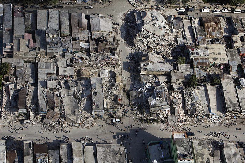
Figura 5. El centro de la ciudad muestra el daño después de un terremoto de más de 7 en la escala de Richter que sacudió Puerto Príncipe Haití justo antes de las 5 pm del 12 de enero de 2010 (foto: Logan Abassi, United Nations Development Programme).
Para ilustrar la diferencia entre la magnitud y la intensidad sísmica es suficiente tomar dos ejemplos recientes: el terremoto del 16 de abril de 2016 en Ecuador (MW = 7.8; Beauval et al., 2017; Nocquet et al., 2017, Vaca et al., 2018) y el del 12 de enero de 2010 en Haití (MW = 7.0; Bilham, 2010). Aunque el sismo de Pedernales, con una liberación de energía 16 veces mayor al de Haití, ha causado un desastre importante en Ecuador y por lo menos 663 víctimas (intensidad máxima X), el de Haití ha causado una gran catástrofe en el pequeño país del Caribe con más de 230 000 víctimas (intensidad máxima >X). Hay muchas razones que expliquen las diferencias en los efectos de esto dos sismos como la ubicación del epicentro (Población área Puerto Príncipe (25 km del epicentro) = 2.6 M habitantes; Pedernales (27 km del epicentro) = 75 500 habitantes) y la calidad de las construcciones (Haití es uno de los países más pobres del mundo, con construcciones de muy mala calidad; Bilham, 2010). Conocer el peligro sísmico y adaptarse a él es la única solución para evitar una gran catástrofe en Ecuador.
To illustrate the difference between magnitude and seismic intensity, it is enough to take two recent examples: the earthquake of April 16, 2016 in Ecuador (MW = 7.8, Beauval et al., 2017, Nocquet et al., 2017, Vaca et al. ., 2018) and January 12, 2010 in Haiti (MW = 7.0). Although the Pedernales earthquake, with an energy release 16 times greater than that of Haiti, has caused a major disaster in Ecuador and at least 663 victims (maximum intensity X), that of Haiti has caused a great catastrophe in the small Caribbean country with more than 230,000 victims (maximum intensity> X). There are many reasons to explain the differences in the effects of these two earthquakes, such as the location of the epicenter (Port au Prince area population (25 km from the epicenter) = 2.6 M inhabitants, Pedernales (27 km from the epicenter) = 75 500 inhabitants) and the quality of construction (Haiti is one of the poorest countries in the world, with buildings of very poor quality). Knowing the seismic hazard and adapting to it is the only solution to avoid a major catastrophe in Ecuador.
Para más información sobre sismos en Ecuador:
IG-EPN: https://www.igepn.edu.ec/
Para más información general sobre los volcanes del Ecuador síguenos en:
Blog: http://ceniza-ecuador.over-blog.com/
Facebook: https://www.facebook.com/volcanesdelecuador
Youtube: https://www.youtube.com/channel/UC7lPStVbhfn_UrhDz4-ObvQ
Instagram: https://www.instagram.com/volcanes_del_ecuador
Twitter: https://twitter.com/Volcan_Ecuador
Literatura recomendada sobre el terremoto de Pedernales del 16 de abril de 2016
Beauval C, Marinière J, Laurendeau A, Singaucho J-C, Viracucha C, Vallée M, Maufroy E, Mercerat D, Yepes H, Ruiz M, Alvarado A (2017) Comparison of Observed Ground‐Motion Attenuation for the 16 April 2016 Mw 7.8 Ecuador Megathrust Earthquake and Its Two Largest Aftershocks with Existing Ground‐Motion Prediction Equations. Seismological Research Letters 88:287–299 . doi: 10.1785/0220160150
Beauval C, Marinière J, Yepes H, Audin L, Nocquet J-M, Alvarado A, Baize S, Aguilar J, Singaucho J-C, Jomard H (2018) A New Seismic Hazard Model for Ecuador. Bulletin of the Seismological Society of America 108:1443–1464 . doi: 10.1785/0120170259
Bilham R (2010) Lessons from the Haiti earthquake. Nature 463:878–879 . doi: 10.1038/463878a
Nocquet J-M, Jarrin P, Vallée M, Mothes PA, Grandin R, Rolandone F, Delouis B, Yepes H, Font Y, Fuentes D, Régnier M, Laurendeau A, Cisneros D, Hernandez S, Sladen A, Singaucho J-C, Mora H, Gomez J, Montes L, Charvis P (2017) Supercycle at the Ecuadorian subduction zone revealed after the 2016 Pedernales earthquake. Nature Geoscience 10:145–149 . doi: 10.1038/ngeo2864
Vaca S, Vallée M, Nocquet J-M, Battaglia J, Régnier M (2018) Recurrent slow slip events as a barrier to the northward rupture propagation of the 2016 Pedernales earthquake (Central Ecuador). Tectonophysics 724–725:80–92 . doi: 10.1016/j.tecto.2017.12.012